Take a look at any Grand Teton National Park map to understand why just driving through is a popular choice. The 42-mile loop of road that circles the Snake River at the park's heart lets you see the Grand Tetons and other spectacular sights without ever leaving your car.
Grand Teton National Park lies on the border of Wyoming and Idaho, immediately south of Yellowstone National Park. The park is full of scenic picnic areas for day-trippers and a heap of trailheads for hikers with serious backpacking in mind. Although the park has more to offer than anyone could conquer in just one visit, it often gets tacked onto Yellowstone itineraries. Named for the majestic Teton Range that runs through it, this bit of beautiful backcountry was placed in the hands of the National Park Service around 1929.
Of course, the park is also a solid destination for backcountry camping. Wyoming is well known for its lack of population, meaning it has less light pollution than many other states. This makes it a perfect destination for stargazers or anyone else just looking to get off the grid.
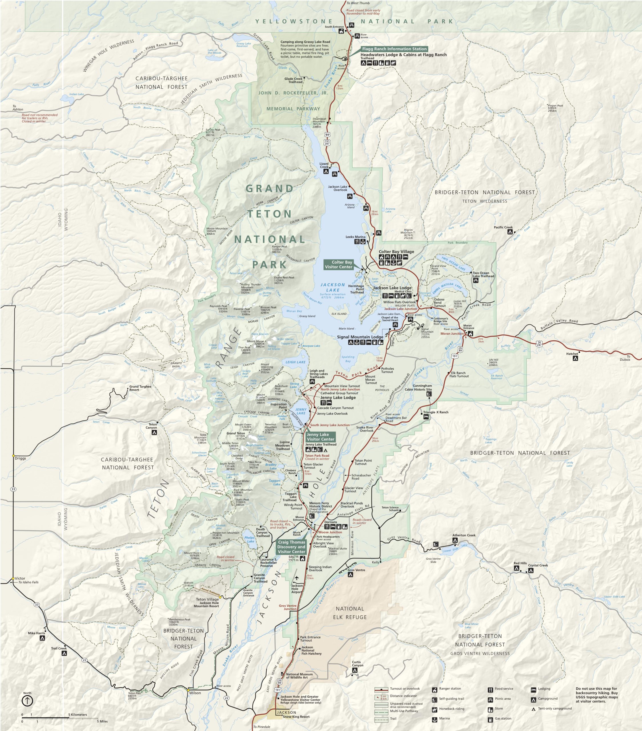
No matter your reason for visiting the Tetons, the map below should help you plan the best trip possible.
Grand Teton National Park Map
As you can see from the map above, the park is flanked by the Caribou-Targhee National Forest to the west and the Bridger-Teton National Forest on its east. Note that both contain campgrounds you might consider overnighting in if the park is full. Similarly, dispersed camping and boondocking are permitted on federal lands, so either forest might be a good place to get some free Z's.
Meanwhile, directly south of the park below the Jackson Hole area, you'll find the National Elk Refuge. It's a great place to stop if you love the area, but you've already had as much of Yellowstone and the Tetons as you can handle. We realize that might be impossible but to each their own.
Finally, if you're looking for a topographic map of the park to help plan your trip, consider checking out National Geographic's Trails Illustrated. They're not free, but they are thorough.
Center Your Trip Around a Visitor Center
https://www.instagram.com/p/B2sROG9lNxZ/
The park has several visitor centers, each of which is close to popular trailheads and other attractions. As such, they act as great bases to build your trip around since you can be sure to find amenities, information, and other conveniences nearby.
Colter Bay Visitor Center
https://www.instagram.com/p/CByHVhLFwsa/
RELATED: Dispersed Camping is the Best Vacation You'll Ever Take
Located in the Colter Bay Village area on the shore of Jackson Lake, this is the northernmost visitor center in the park. If you're entering the park from the North, it's the first bit of real civilization you'll reach following the Flagg Ranch Information Station and Headwaters Lodge on the John D. Rockefeller, Jr. Memorial Parkway. More importantly, the Colter Bay Campground and RV Park are both found here, and they're the first campsites you'll come across following the park's most northern ground, Lizard Creek.
Just a little further down the road, you'll hit Jackson Lake Lodge and Signal Mountain Lodge, the latter of which isn't far from the road that leads to Signal Mountain itself. Both of the lodges and the Colter Bay Visitor Center have accommodations, gas stations, and more. As you can see on the map, the region is packed with lakes, rivers, and trails and is close to the park's east entrance.
Jenny Lake Visitor Center
https://www.instagram.com/p/CC_—oIlZ4s/
Wander smack-dab into the middle of the park, and you'll come across this welcoming outpost. As its name suggests, it is situated on the shores of Jenny Lake. A campsite with the same name is stationed here as well.
The area surrounding this visitor center offers some of the best views of the Tetons the park has to offer, not to mention other titans like Mount Moran. Additionally, a shuttle boat crosses the lake to Hidden Falls, Cascade Canyon, and a handful of popular trailheads. Many of these lead to large bodies of water like Leigh Lake and String Lake and mere ponds like Taggart Lake.
Craig Thomas Discovery and Visitor Center
https://www.instagram.com/p/CGklo_gHe9v/
The southernmost visitor center is closer to destinations like the turnoff for Teton Village, Jackson Hole Airport, and the Phelps Lake area, crossed by several trails. The park's headquarters at Moose Junction is right across the road and some basic amenities. The Gros Ventre campground is a short drive east and south.
When is Grand Teton National Park Open?
https://www.instagram.com/p/B11aDcPl-pc/
Believe it or not, the park is open 24 hours a day, 365 days a year. That being said, Winter can drop some serious weather to the park that might bring select closures with it. To make sure your trip is a success, contact park authorities regarding conditions before your visit.
Have any travel suggestions for folks visiting Grand Teton National Park? Please spread the word on our Wide Open Roads Facebook!
